March 11, 2011 (five years ago), a mega earthquake hit the east of Japan with a magnitude of 9.0 on the Richter scale – the largest earthquake in recorded history to hit Japan. The earthquake resulted in several spatial land waves and also an enormous tsunami which devastated the east coast of Japan. Generally, earthquakes frequently occur along the coast, prompting the government and private sector to create shelters, break-waters, and evacuation routes. Even with proper active mitigation practices, multiple natural disasters in the past have caused destruction to infrastructure such as homes, factories, fisheries and ports.
Geophysically, the subducting boundary along the “Ring of Fire” of the Pacific Oceanic Plate that exists near the Japanese peninsula succumbed to built-up pressure, triggering the movement of the plate and causing the earthquake. This subduction set off a chain reaction, generating a tsunami that impacted the east coast of Japan, especially damaging the inner bay and shallower areas. In shallow areas, reflected waves combine with in-coming waves in-phase to create even higher waves. Shallower bottom friction reduces the phase speed leading to intensification of the wave height of the tsunami as the wave propagates towards the coast.
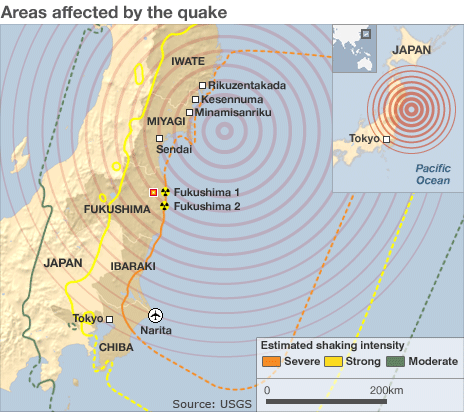
One of the most devastating effects, however, was the damage of the nuclear plant in Fukushima. The resulting radiation leak spread a few hundred kilometers from the plant. To this day, residents from the area are still unable to return to their homes. Long-lasting impacts were also evident in water-borne contaminants and litter including radiated water propagating with the Kuroshio current northwards along the western coast and then off to the east, crossing the Pacific Ocean and eventually making its way towards the continental United States. Samples of these materials have been found along the west coast of the US. Coastal industries such as fisheries within the region where the disaster occurred were also affected by the radiated waters. Marine-based food sources were severely compromised through significant die-off and being rendered unfit for consumption following exposure to radiated waters.
For the Caribbean Region, historically potentially destructive tsunamis occur at an average rate of 1-2 per century in the Caribbean. Tsunamis due to local earthquakes and volcanic eruptions are higher in frequency while those caused by distant earthquakes pose lower threat. Currently, for earthquakes that can or have triggered a tsunami that may affect the Caribbean, the Pacific Tsunami Warning Center (PTWC) will send a warning to specific agencies in the Caribbean such as the Seismic Research Centre of the University of the West Indies. The PTWC and Japan Meteorological Agency’s North West Pacific Tsunami Advisory Centre (NWPTAC) played a crucial role in Japan’s responsiveness. The 2011 tsunami could have been even more devastating, however, if it were not for the preparedness of Japan’s disaster management programme at local responsiveness and mitigation, keeping the death toll at lower numbers compared to Indonesia’s 2004 tsunami. The lack of a comprehensive warning system for the Caribbean that incorporates communicating with and mobilising the general public remains a significant risk factor in disaster response for the Region.