About Coastal Dynamic Modelling Laboratory (CDML)
The Coastal Dynamics Modelling Lab is the visualisation and data portal of MGIBlue, the coastal studies division of the Mona Geoinformatics Institute, University of the West Indies, Mona Campus, Jamaica. We specialise in depictions and analysis of coastal processes that affect our way of life along our harbours, shoreline infrastructure, cays, beaches and marine habitats.
OSCAR ocean surface current flow models around Jamaica: strong persistent east-west flow is the Caribbean Current south of Jamaica; otherwise, smaller-scale eddy systems immediately surround the island, increasing complexity and variability in near-field flow as you approach the shoreline.

IPCC climate change report 2013
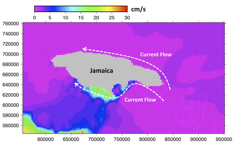
Pattern of the Ocean Current around Jamaica. The coordinate system (x and y axis) is applied JAD2001
Goals
The CDML aims to :
- Highlight coastal dynamics work carried out around Jamaica, its fishing banks and the larger Region.
- Engage researchers to use CDML for developing new ideas, facilitating publications and contributing to policy affecting our marine areas.
- Build a repository of forecasted and measured data on various coastal physical processes, such as tides, wind, wave, currents, sediments etc. for the Region.
- Inform broader issues and mitigation of impacts from hazards such as sea-level rise, tsunami waves, eroding beaches, sand-mining onshore and offshore, oil spills, effluent discharge, as well as water-borne contaminants and invasives dispersal in the management of our coastal and offshore areas.
Why is ocean circulation so important?
The ocean covers nearly three-quarters of our planet. It contains 97 % of the planet's water, producing oxygen for and absorbing carbon from the atmosphere. Ocean circulation is important for balancing climatologic conditions, including maintaining temperature and influencing global warming. It also provides humans with food and other resources for surviving. In recent times, human activity has caused accelerated global warming by the green-house effect, significantly increasing sea level rise by sea-water expansion and ice-melting. Anthropogenic warming is predicted to result in intensification of hurricanes, typhoons, storm surge, ground water salinization and drought - all factors that can create natural disasters in built-up or heavily populated coastal areas. The ocean is crucial in many ways for maintaining the balance of Nature. Numerical hydrodynamic models are ideal for simulating the movement and quality of our oceans. Scientists use these models to describe and predict this constantly active environment. Information on forcing factors and conditions such as tidal levels, bathymetry, wave height, current flow and the water quality are fed to the models which then use complex formula and computations to produce simulations depicting the state of our environment. These outputs are useful in informing you about impacts such as where currents are strongest or weakest; how a river affects temperature, salinity and sediment distribution along our coasts; where fish larvae are likely to end up and thrive; distribution of an oil spill; parts of the coast highly susceptible to erosion and flooding from sea level rise - all examples of important factors to consider in managing our marine and coastal environments.