Detailed sanctuary habitat maps were created by MGIBlue of Jamaica’s south coast, providing critical information on these environments important for sustaining marine life and ecosystems. Maps display the distribution of eight benthic habitat types: Hard Coral, Mangroves, Mud, Pavement, Rubble, Sand, Sparse Sea Grass and Dense Sea Grass. These were created for the project “Classification of the Fish Sanctuaries – Habitat Mapping” implemented by the Fisheries Division, Ministry of Industry, Commerce, Agriculture, and Fisheries. The Government of Jamaica will use these habitat maps to support decision-making for marine planning, management and policy-making.
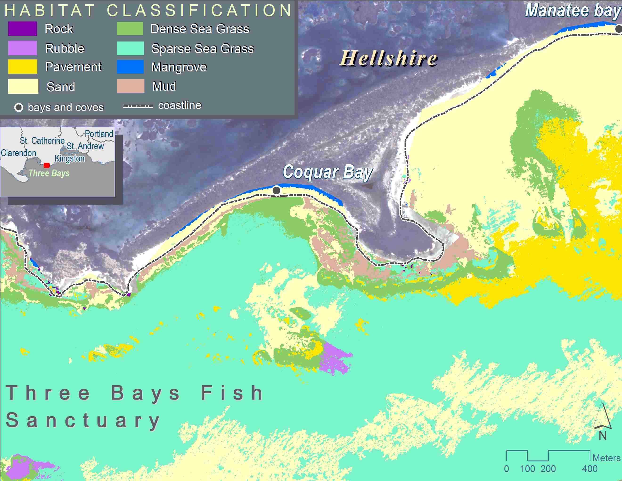
Fig 1: Three Bays Fish Sanctuary habitat classification map (left) and chart of proportions (below). This sanctuary displayed the highest diversity of all sanctuaries mapped.
 Since 2008, the Fisheries Division has set about establishing several Special Fishery Conservation Areas (SFCAs) to aid in reducing the negative impacts of fishing pressure on fisheries resources. Establishing a baseline now allows monitoring of the health of sensitive habitat types as climate change impacts are projected to affect these environments.
The technical approach involved a combination of remote sensing, field testing and spatial analytical techniques. First, multi-spectral satellite imagery was collected for four sanctuaries, all located along the south coast (Bluefields Bay, Galleon Harbour, Sandals Whitehouse and Three Bays); secondly, the imagery were processed to derive unique spectral signatures for each classification; thirdly, the classifications were validated through field collections; and, finally, cartographic outputs and statistics were created of the classification outputs.
Of the combined area of forty-seven square kilometers surveyed, results showed that dominant habitat types were Sea Grass (49%) , Mud (22%) and Mangroves (14%). There was very little Hard Coral present (0.2% of all areas combined), validating concern for the diminishing state of coral reefs along Jamaica’s coastal areas. Three Bays (St Catherine; Fig 1) and Bluefields Bay (Westmoreland) SFCAs were noted to carry highest diversity of habitats – an advantage for encouraging variety in marine life and withstanding adverse environmental impacts. Sandals Whitehouse (Westmoreland), the smallest of the SFCAs, is over-run by Sparse Sea Grass (74%), significantly lowering its diversity. This SFCA is therefore the most susceptible to impacts, where most the area will be adversely affected should anything prevent its seagrass from flourishing. The Galleon Harbour (St Catherine) SFCA stands out as being primarily made up of Mud and Mangroves, classes which are found in minute quantities in other SFCAs. It is likely that Galleon Harbour can therefore support unique mangrove- and mud-loving types of marine life that may not flourish in other SFCAs. Future grants will continue to: apply this mapping technique to other SFCAs located around the island; assess changes within these sanctuaries; and attempt to determine the triggers for these changes.