
Figure 1: Map illustrating the epicenters of the many earthquakes that struck the island of Sulawesi – The Telegraph UK
Between September 28thand 29thof 2018, the island of Sulawesi, Indonesia was hit by dozens of earthquakes (see Figure 1), the most significant of which being of 7.5 magnitude and 10 km deep, approximately 80 km north of the coastal city of Palu. These earthquakes occurred along the Palu-Koro fault, which is a strike-slip fault zone, and typically less likely to be at risk for significant tsunami waves. Other conditions, however, increased the risk. Specialists speculate that a submarine landslide occurred within Palu Bay and that the geomorphological feature of the long, semi-enclosed – almost U-shaped bay – heightened the effects of the tsunami, see Figure 2.

Figure 2: Map depicting the epicenter of the earthquake suspected to have sent tsunami waves into Palu Bay – The New York Times
Considering its location in the infamous Ring of Fire, a major area in the basin of the Pacific Ocean where roughly 90% of earthquakes occur, Indonesia should be among the most educated and best prepared societies to deal with earthquakes and their associated events. After the Boxing Day tsunami in 2004, one of the deadliest ever recorded with over 230,000 deaths, Indonesia and other governments in this region established an early tsunami warning system. According to locals, however, this system failed; there was no indication of the impending 6-meter (20 foot) waves that devastated the coastal towns along Palu Bay, see Photo 1. Gavin Sullivan, an associate professor at Coventry University who studies disaster preparation and recovery in Indonesia stated, “Many people at the beach and on the [bayside] road had no idea the wave was coming at all.” Though the island of Sulawesi is equipped with tsunami sirens and even a text-message alert system, both failed due to damages incurred by the earlier earthquakes.

Photo 1: A mosque lays in pieces in Palu; this depicts just some of the destruction on the island of Sulawesi following the earthquakes and tsunamis – BBC
Some specialists argue that although there were technological failures with the alert system, it wouldn’t have mattered because of the localized nature of the tsunami. Phil Cummins, a professor of natural hazards at the Australian National University, explained: “in that case you can’t rely on a warning system; people should seek high ground immediately. They cannot afford to wait for a siren or a warning – they need to move instantly.”
Jamaica similarly lies on a strike-slip fault zone, meaning that though we often feel earthquakes, the forces generated are rarely enough to cause tsunamis. This does not mean that it is impossible for one to occur. In fact, two of Jamaica’s strongest earthquakes (Port Royal 1692 and Kingston 1907) were coupled with catastrophic tsunamis. In both of these earthquake events, there was significant land displacement into the sea, significantly contributing to those tsunamis (see Photos 2 – 4).
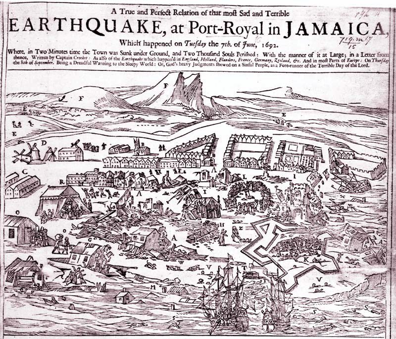
Photo 2: An engraving depicting the damage at Port Royal, Jamaica, following the series of earthquakes and tsunamis in June of 1692. Much of the port was built on loosely packed soil, not bedrock, and so a large portion of land was displaced into the Sea – www.insh.world


Photos 3 & 4: The famous Giddy House at Fort Charles in Port Royal, Jamaica; the 1907 earthquake/tsunami event caused significant damage at the Fort, including the partial swallowing of this building – Stéphane DAMOUR/Flickr (3) & Prips Jamaica (4)
As recently as January of this year (2018), Jamaica received a tsunami warning after a 7.6 magnitude earthquake hit between the Cayman Islands and Honduras. Figure 3 illustrates the areas that likely would have been impacted by a tsunami-sized wave had the event been even more powerful and/or shallow. Two areas stand out in their shape being semi-enclosed and elongated similar to Palu Bay – Portland Bight and Kingston Harbour. Their geomorphology make them prone to similar effects from submarine landslide-induced tsunamis. Though the warning was quickly lifted and no tsunamis were recorded in the region, it served as a wake-up call to much of the Caribbean where there aren’t active tsunami preparedness plans in place. Although the island has been lucky enough to only experience 4 major earthquakes (greater than a magnitude of 5) in the last 4 centuries, we must still acknowledge that Jamaica lies in a fairly seismically active zone. As Dr. Parris Lyew-Ayee of the Mona Geoinformatics Institute stated in response to the apathetic public reaction to the recent scare, “The best lesson for complacency is a “lick” and we don’t want a “lick”.”

Figure 3: Map depicting the areas that would likely be affected by a tsunami in Jamaica if triggered by an event stronger than the January 2018 seismic activity east of Honduras– Source: MGIBlue – Mona Geoinformatics Institute
The science surrounding early tsunami detection is still imperfect, as earthquakes are still extremely unpredictable. While scientists are able to track levels of tension along fault lines and can estimate the probability of a seismic event, there is still no accurate way to predict exactly when an earthquake will occur. When an earthquake does occur, however, agencies like the National Oceanic and Atmospheric Administration (NOAA) use the information from the seismic waves and a sophisticated buoy/satellite system to forecast any possible tsunami activity. As Sulawesi’s tsunami taught though, sometimes these early detection systems are faulty and warning messages may not be received in time. That is why the government of New Zealand stresses the importance of natural warning self-evacuation for coastal regions summarized in the saying “long or strong, get gone”; emphasizing the need for precautionary evacuation to higher ground if one feels a long or strong earthquake while in a coastal zone. The key to surviving a tsunami, much like other natural disasters, lies in preparedness and education.