White sandy beaches, integral to the Caribbean way of life, are being engulfed by Sargassum, transforming these pieces of paradise into a repugnant state, with rotten stenches and unsightly piles of algae that not only release toxic fumes but are also highly efficient at trapping waterborne solid waste litter. The precarious nature of Small Island Developing States (SIDS) is exacerbated by Sargassum inundation as it is highly disruptive to both fishing and tourism sectors, two of the region’s major contributors towards Gross Domestic Product (GDP). With climate change, pollution and natural climatic systems continuing to drive the influx of seaweed into the region, the harsh truth is that Sargassum is here to stay. Caribbean nations will have to find innovative and preemptive measures to reduce the impact of the seaweed on livelihoods. Work done by the Mona GeoInformatics Institute as part of the ‘Teleconnected SARgassum risks across the Atlantic: building capacity for TRansformational Adaptation in the Caribbean and West Africa’ (SARTRAC) project is hence crucial in fighting this novel threat.

Sargassum is a floating brown macroalgae seaweed that has been washing upon Caribbean shorelines in copious quantities since 2011. With the SARTRAC project well underway, MGI has so far established state-of-the-art techniques of quantifying beached Sargassum along Jamaica’s coastline. A combination of geospatial, field, remote sensing, and social survey techniques have been developed to ascertain data which has proven critical in garnering insights on the beaching of Sargassum and its subsequent impact on various societies and sectors along the nation’s coast. In fact, the team has been active across Jamaica and has conducted multiple field visits in the communities of Negril, Hellshire, Manchioneal, Long Bay, Kensington, Robin’s Bay, Salt River, Port Royal and Priory.

As next steps in the project, MGI aims to establish the work done under SARTRAC as a legacy by imparting the technical skills required to conduct Sargassum monitoring to the National Environment and Planning Agency (NEPA), as well as various fishing communities across Jamaica.
This is a critical step in the overall management of Sargassum. Only when a synchronous method of evaluating beached Sargassum across monitoring agencies island-wide is established, will we able to adequately evaluate the problem and develop effective management strategies to alleviate issues arising from the inundation of the seaweed. This work will also assist MGI in the development of a Jamaican Sargassum Early Advisory System.
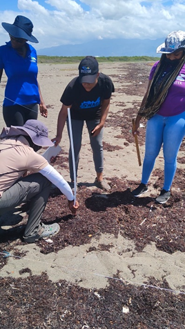
MGI recently visited Port Royal in August 2022 with a team from NEPA to transfer knowledge through training in techniques and mapping equipment as it relates to Sargassum monitoring. NEPA for years has been tasked as the government agency managing sargassum beaching issues across Jamaica.

During our training exercise, MGI specifically trained NEPA with resources to:
- Perform Rapid Assessment of beached Sargassum
The Mona GeoInformatics Institute developed an electronic beached sargassum data collection form, jointly with NEPA, that assists in monitoring by being less resource-intensive when compared to other methods. The development of this electronic form would save monitoring agencies both finances and time spent in the field. The form aims to efficiently capture essential, quantifiable parameters of Sargassum.

- Utilize field methods to measure the volume of Sargassum beached along the coast
Utilizing field transect methods is by far the most useful and accurate method of evaluating severity of beached Sargassum. This data may be especially useful to sectors affected by the depth and volume of beached Sargassum, such as fisheries where deep mats increase the difficulty of fishermen launching their boat, as well as tourism and recreational interests where heavy sargassum inundation prevents utilisation of beaches. Entrepreneurs interested in the conversion of sargassum for commercial purposes would also find this data crucial for establishing feasibility and meeting demand.
- Perform drone imagery captures that provide area measurements of beached Sargassum
Estimation of area captured by drone imagery is a highly time-efficient method. This method may be more applicable as a means of monitoring for those stakeholders wanting to calculate the area of cover such as hotels and recreational interests whose activities are directly impacted by the coverage of Sargassum on the beach. Another advantage of this method is that it quickly quantifies Sargassum cover over larger areas as opposed to small samples captured by field methods.


SARTRAC is a 3-year joint programme of research funded by the Economic and Social Research Council (ESRC) Global Challenges Research Fund (GCRF) and led by the University of Southampton with partners from the Caribbean and Africa including: the Mona Geoinformatics Institute (MGI) and Centre for Marine Sciences – both based at the University of the West Indies Mona, Jamaica; Centre for Resource Management and Environmental Studies (CERMES) – based at the University of the West Indies Cave Hill, Barbados; and University of Ghana. MGI’s Dr Ava Maxam co-leads on the Monitoring and Dissemination work package tasked with two main objectives:
- DISTRIBUTION. Using a myriad of cutting-edge technologies such as the use of drones, remote sensing analysis of high-resolution satellite imagery and Geographic Information Systems (GIS), the project monitors, tracks and maps Sargassum movement and impact across the transatlantic basin at local and regional scales.
- DRIVERS. Drivers of Sargassum remain poorly understood and as such the project aims to contribute to this area by examining both global and local scale drivers of Sargassum across the transatlantic region from the Caribbean to Africa.
Techniques and insights have also been transferred by MGI to the team in Ghana for bolstering their sargassum monitoring.
Outputs garnered from these objectives will ultimately result in the development of a Jamaican Sargassum Early Advisory System to allow key sectors and communities to better prepare for prolific inundation events.
To find out more about Sargassum and the work being done by MGI to tackle the issue, feel free to reach us at info@monainformatixltd.com.
Also, read more about the SARTRAC project here ( https://blue.monagis.com/sartrac-project-update-01-mgi-and-its-partners-awarded-united-kingdom-research-innovation-ukri-grant/ ).
See Television Jamaica’s (TVJ) news coverage documenting our training session here: